Category Archives: Times & Places

Short historical articles about Camano-island and-Stanwood-area

East Stanwood Busy Corner

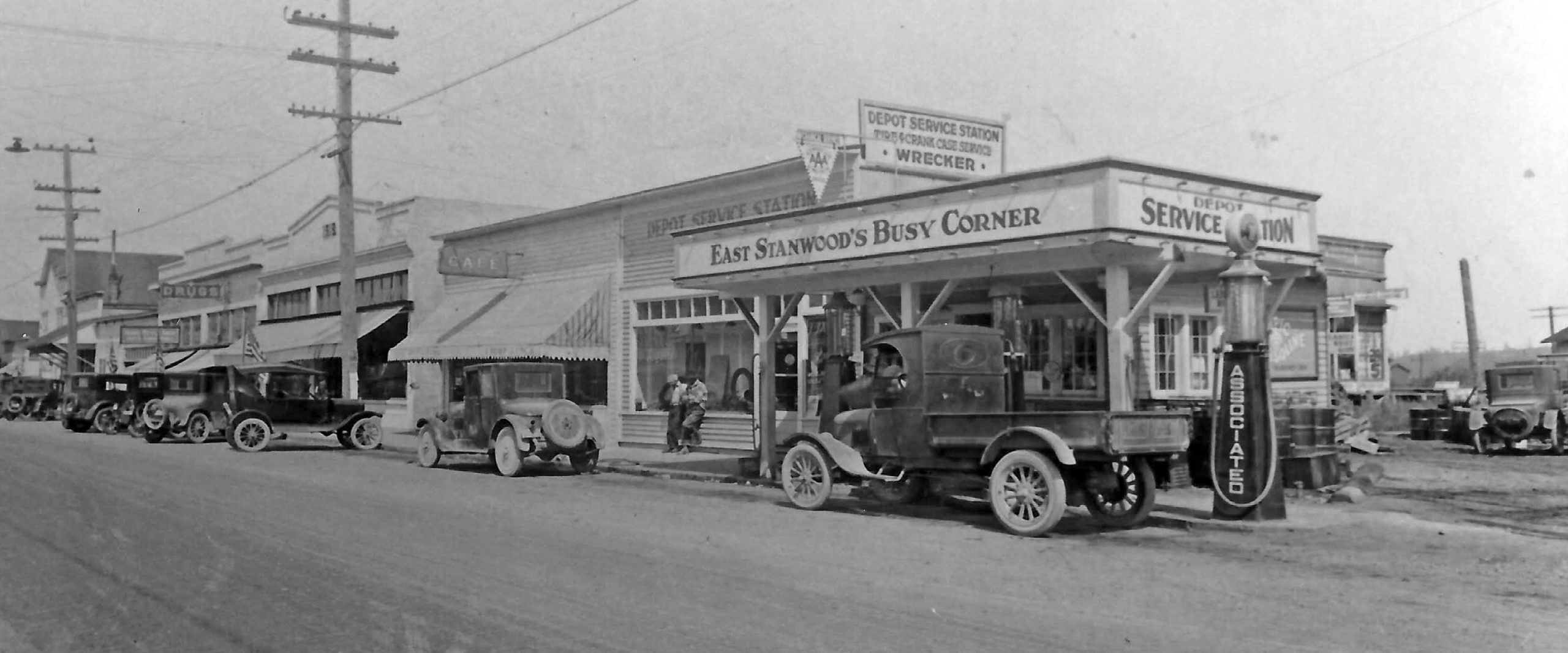
This view shows North side of 271st St NW in Stanwood looking northwest.   From left the buildings are the Granary (distant left, originally known as the People’s Union), an unknown storefront, the N. V. KIng Building (1921), the 1918 Mercantile (behind the telephone pole), a cafe and the Depot Service Station garage with its East Stanwood Busy Corner sign. The cafe and service station burned in 1997. Photograph from the SAHS Collection 1995.28.21.

Some might be aware that Stanwood was once two towns: Stanwood (near river) and “East Stanwood” (near the railroad tracks).

The corner just east of the Stanwood Station had a small gas station with an awning that advertised itself as East Stanwood Busy Corner.   It was a popular stop on the Pacific Highway between Everett and points north before Stanwood was bypassed in the 1930s,

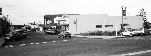
In August 1997 the historic buildings that were once the Depot Service Station, a garage and the café (next door) burned in a two alarm fire.  The businesses in the buildings at the time were the Eastside Salon, the gift store Emma’s Cottage and the antique shop, Yo Mama’s Attic.  Firefighters prevented the fire from spreading to other businesses but managed to save the 1918 Mercantile.  The owner at the time had to demolish the fire damaged buildings and currently that space is a grassy open space across from the Stanwood Railroad Station.  Read on..

The white concrete building is the East Stanwood Mercantile popularly know as the Stubb Mercantile.

When the museum opens again for visits, you can see a small exhibit that displays more photographs of this story but for now, perhaps this property can be the first East Stanwood Busy Corner Park as part of the City of Stanwood’s Main Street Revitalization Program.

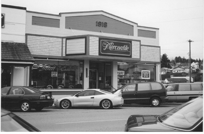
The Mercantile.  Photo taken in 2003.

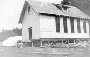
The original 1914 East Stanwood Mercantile store business was established by Otto Stubb and Andrew Frederickson. In 1917 Frederickson sold his interest to Otto Stubb but in 1918 the building was destroyed in a fire. The new concrete building that still stands was completed in October 1918.  But there could be no grand opening ceremony because of the Influenza epidemic. (Stanwood News Oct 18, 1918).  One month later, the Armistice was signed ending World War I.      See below…

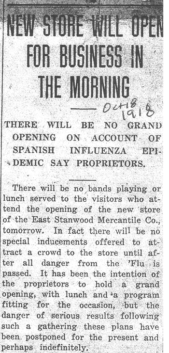
Opened to the public Oct 19…”The building is certainly a credit to the community … [who] will wish the proprietors, Messrs. Otto Stubb and O. C. Amundson the best of luck…”  Stanwood Tidings Oct 18, 1918.

A Short History of Barnum Point

View of Barnum Point from road east of  Triangle Cove of the sight of the original Barnum home. The park is not accessible from this point. The new entrance is from parking lot near the end of Sunrise Blvd. Photo taken 2019.  See our 2020 calendar for a historical view of this historic place.

Our treasured new Island County park on Camano Island, like our others, has an unusual history.  The 166 acres that is now a park was a single landowners property since about 1904 when it was purchased by Sterling J. Barnum.  His early ownership undoubtedly coined its name. The United States Board of Geographic Names describes Barnum Point on Camano Island as a cape.  With its steep south facing cliffs it is a prominent geographical feature in Port Susan and now a stunning Island County park with wide panorama views of the Cascades and Mount Rainier.  The point or cape is now an Island County park with stunning views of the Cascades and woodlands in Port Susan.  Its history is still to be found in the vegetation, fields and woodland trails.  We are forever grateful to the family for making this available to us.

Metsker Maps, and Chas. F. Metsker. Metsker’s County Atlas: [Island County, Washington]. Tacoma, WA: Metsker Maps, 1949.

In 1904 when Sterling Barnum bought the property, a second phase of logging had begun after the Utsalady Milll closed a decade earlier.  The Camano City area was growing and Livingston Bay had several surrounding farms.  The family’s history here begins with Sterling Barnum (1868 – 1936) who came from Binghamton New York to be near the water.

In their earliest days according to accounts by his daughters the Barnum family fished and raised Rock Island Red chickens, sheep, cows, pigs, vegetable gardens and a large orchard. They lived on what they produced and had little association with Stanwood. Potatoes and some oats were their cash crops.   They also grew strawberries that ripened before other farms because of the long afternoon sun. Their only modern convenience was a telephone at the time

The bridge to the island wasn’t built until 1909 and the road from Stanwood where there was a ferry crossing, only went as far as Terry’s Corner.  Before the bridge, the family made only a few trips a year to Stanwood on a scow or a rowboat.  Usually supplies were picked up by the steamer or scow that brought supplies to the mill across the cove before there was a road.  They went in on the incoming tide and came back on the outgoing tide. The children rode their pony to Terry’s Corner to pick up mail.

In 1908 Barnum was instrumental in establishing the Central School (Island County District #21) for his children and others in the vicinity so they would not have to travel all the way to Utsalady or Camano City.  Classes were first held in the Evans home, neighbors of the Barnums.  A school building was originally constructed at the corner of Russell Road and Barnum Point road and eventually moved to property just north to the current location of the Island County Sheriff department.

Mr. Barnum served one term as County Commissioner from 1914-1915 to promote road building on the island and by the 1920s the Island was welcoming auto traffic through Stanwood.

Inn at Barnum Point Sign, 2006 – This sign now removed but once marked the entrance to the Barnum Point Inn from the early 1990s until about 2013.

A few family members stayed on or used it as a summer place.  The most recent memory of popular access was the construction of Barnum Point Inn, a new bed and breakfast built in 1992 or 1993 by Carolin Barnum DiLorenzo.  She operated it for about 25 years.

The property remained in the family’s hands until the 2010s when family members could no longer support the property.  In about 2013 they began negotiating with community groups interested in preserving this spectacular and undeveloped geographic feature that could have been sold for residential development.  Purchases of different sections were made over a period of years and final purchase was made and the park became complete with a new parking lot in 2019. Funding for the purchases came from Island County, Washington Wildlife and Recreation Program, Washington Salmon Recovery Funding Board, U.S. Fish and Wildlife Service, and Washington Department of Ecology. To start off the successful fundraising campaign, more than 600 private donors responded with proactive support from Whidbey Camano Land Trust , Friends of Island County Parks, and many other volunteers.

c. 2020; Stanwood Area Historical Society and Karen Prasse;  All rights reserved.

1952 F-89 Plane Crash over Camano Island

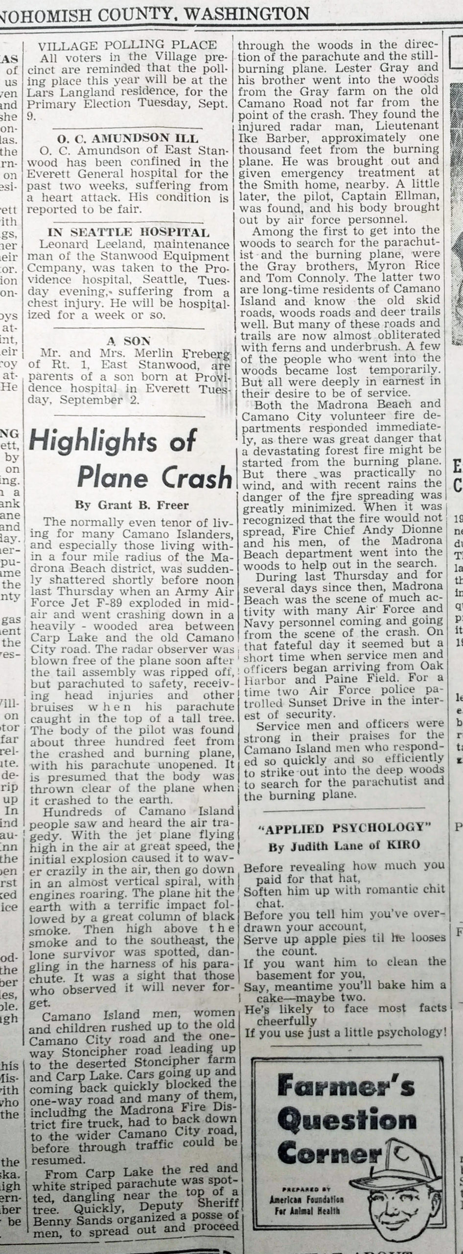
Finally after several tries to find an article documenting a mysterious 1952 plane crash remembered by several members of the Historical Society, we finally found it.  No one could remember the year so that made it hard to verify the story.

Scroll down to read the full account provided by local Stanwood News reporter of the day, Grant Freer.

The pilot died but the radar operator survived,  More Details on the F-89 aircraft for airplane history enthusiasts are here (pdf download)

There is an F-89 D at the Skagit Heritage Museum in at the Skagit Regional Airport in Burlington.

As always – please send along what you heard that day when the plane crashed.  Click the Contact Us link at the top of the site…

—Karen

Plane Crash over Camano 1952